| |
The History of Milam's Gap / Fisher's Gap
"For the Staunton Spectator
Madison Court House, November 27th, 1862
Editor of the Spectator -
"On the third day out, we crossed the Blue Ridge at Milan's (?) Gap, where the turnpike scales the mountain by a serpentine grade of seven miles to obtain a distance of only one as the crow flies. The army was marching by brigades, each brigade followed by its own artillery and wagon train; they stretching for miles and miles along the turnpike, up the mountain side, and far across the Page Valley to the Massanutten range. The troops and trains winding the turns of the grade up the mountain were at times all in sight and seemed moving in every possible direction, 'In wondering mazes lost'.
"The soldiers were often in speaking distance of each other, though really far apart, and going in opposite directions. The jests and taunts that passed thus at safe distances from crag to crag served to cheer them on their toilsome tramp--The lucky wearers of high shoes were urged to "come out of them shoes! I know you're in thar! I see your head stickin' out." Men in big overcoats were assailed with--"Overcoat, let that man out! I know you've got him in thar, I see his fingers and toes workin'." Many witty and contemptuous comparisons were made of this mountain passage with Hannibal's and Bonaparte's boasted crossing of the Alps!
"Many of the men are yet without shoes in some of the regiments, and it is most piteous to see them painfully picking their way along through frost and ice. Many are without blankets, and how they stand it, is more than can be imagined by those of us who are so fortunate as barely to escape freezing under two blankets by lying out in these frosty nights. "
"....The soldiers, however, are wonderfully cheerful. They live, too, in hopes of seeing an end of the war....
"Yours &c., &c." [206]
{To read the full text, click here (link) - see page 2, column 4.}
The reporter recounted the crossing of the Blue Ridge by much of General Thomas J. "Stonewall" Jackson's Corps from the Shenandoah Valley to join General Robert E. Lee in the defense of Fredericksburg. It is one of the rare references to a gap on the Blue Ridge Turnpike, or the Gordonsville Newmarket Turnpike, which was referred to as Milam's Gap. That there were apple orchards - and indeed apple brandy (apple-jack) - near Milam's Gap was made clear by Capt. James Cooper Nisbet's colorful account of this crossing in his memoir, Four Years on the Firing Line:
"On November 21st we bade the valley.....goodbye....; and commenced our march down the valley. We proceeded through Winchester to New Market, where the head of the column turned toward the Blue Ridge....
"When our {turn}pike road leading across the Blue Ridge turned up the Hawks Bill Valley, our boys struck a lively gait.....We were halted for a ten minute rest, as was customary with Jackson's Corps, after marching two miles. My company requested me to make a detail to take canteens and buy apple brandy for all that wanted it..... When we made the Valley Campaign in the Spring our men had found Kite's still-house at the head of Hawks Bill Valley, at the foot of the mountain. When the detailed men went through the big apple orchard and got to the still-house they were halted by a cavalry guard, who said that General Jubal Early commanding Ewell's Division had forbidden Kite selling brandy to his men. This being reported, the regiment led by Captain Hamilton broke ranks and went over there. Captain Hamilton asked the lieutenant of the guard if General Early got any brandy as he passed? He answered: "Yes, he had his canteen filled and the keg behind his ambulance." Captain Hamilton said: "Then we will buy what we want," and told old mate Kite to use certain men to draw the liquor and to receive the money. When we had bought what we wanted other regiments were served as they arrived.
"The pike road leading across the Blue Ridge to Madison Court House winds up the mountain by an easy grade. It was a cool November afternoon, the brandy warmed the boys up and made them hilarious. They sang corn-shucking songs. One of my men, Riley Thurman, who had a remarkably fine voice, led. The whole brigade joined in the chorus, which they could do well, as the leading regiment was often close to the rear of the brigade on account of the windings of the road.
"General Jackson caught up with us, and in trying to pass on was caught in the jam and had to listen to some very risque couplets. The austere Presbyterian elder could not hide his amusement at the cheek of the fellow leading. He did not seem to be worried that his twenty thousand veterans felt happy and light hearted." [207]
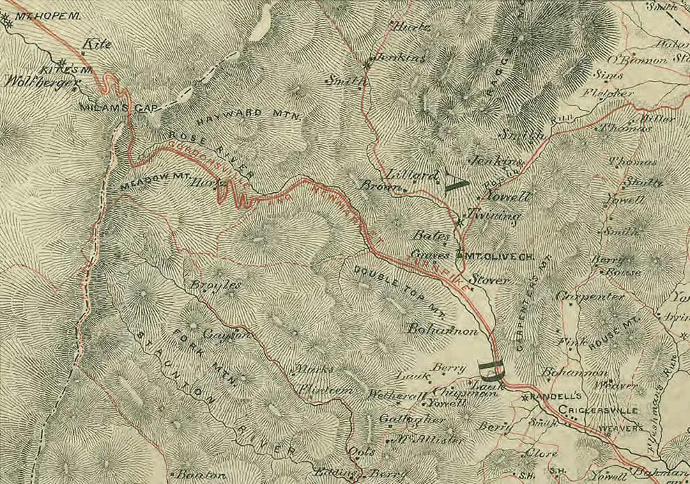
{In the upper left corner of Jeremy F. Gilmer's 1864 map above, there is a "Kite" homestead identified just to the northwest of Milam's Gap.}
At the outbreak of the Civil War there were no reliable maps of the areas in which the battles would be fought. Although the Atlantic and Gulf Coasts and the Great Lakes had been charted in detail for navigation purposes, there didn't appear to be any commercial need to produce detailed maps of the country-side. [208] { For a history of mapping by Richard W. Stephenson, click here (link) . }
Since I moved to Virginia in 2005, I have searched the map collections at the Library of Virginia and the Virginia Historical Society for the earliest map with Milam's Gap on it. Neither the famous 1751 Peter Jefferson-Joshua Fry's Map of Virginia nor the 1776 Eugene M. Scheel's map of Culpeper and Madison Counties nor the 1821 John Wood's map of Madison County nor the 1848 Claudius Crozet's Map of Internal Improvements of Virginia show a pass at Big Meadows or even a road along the Rose River. This was because there was no road crossing the Blue Ridge at this gap until the state chartered Blue Ridge Turnpike Company completed the Gordonsville Newmarket Turnpike in early 1853. At the Library of Virginia, I reviewed the Board of Public Records file for the Blue Ridge Turnpike Company, Item No. 215, and the drawing for the proposed turnpike, Item No. 549. Alas there was no mention of the name of a gap in the corporate filings and no indication of a gap on the drawing - very disappointing! But this speaks to the insignificance of the place prior to the turnpike.
Fortunately for General T. J. Jackson, he found Jedediah Hotchkiss: a native of Windsor, New York, who graduated from Windsor Academy and settled in the Shenandoah Valley where he became principal of Mossy Creek Academy. On the side Hotchkiss studied engineering, geology and map making. More than half of the maps in the Atlas to Accompany the Official Records of the Union and Confederate Armies were prepared by Hotchkiss who also kept a detailed journal and whose letters to his wife and others largely survived. [209] Hotchkiss's sketch books, original maps and journals were donated by his family to the Library of Congress. The 341 drawings and maps may be viewed and downloaded here (link). We can follow Hotchkiss' search for the name of the gap through these records.
Hotchkiss responded to Virginia Governor Letcher's 10 March 1862 call out of the Shenandoah Valley militia and requested service with General Jackson as a topographic engineer (map maker). When on 26 March he first met with Jackson, the General soon got to the point: "I want you to make me a map of the Valley, from Harper's Ferry to Lexington, showing all the points of offense and defense in those places....Good morning, Sir." [210] From time to time, he was requested by Jackson to prepare local maps and to identify the best route of attack or the most defensible position. Hotchkiss' published military journals, Make Me a Map Of the Valley, recounts an April 1862 reconnaissance of interest to us:
"Monday, April 21st
"The General ordered me, at an early hour, although it was cold and raining very hard to ride to Swift Run Gap and find a concealed road by which we could flank attack on a portion of the enemy....I returned and reported to the General and then learned that he had named the wrong Gap. He intended to send me to Milham's, or Fisher's Gap, on the road from New Market to Madison Court House....After feeding my horse I again faced the storm and road to Furnace No. 2 where I got Mr. Henry H. Propes, a former student of mine at Mossy Creek as a guide, and we rode up the North Fork of Naked Creek, behind a low range of mountains....to Graves' on the head of Hawk's Bill Creek, 19 miles, on the road from Columbia Bridge to Fisher's Gap where I got information about the enemy encamped at Columbia Bridge.
We then road back to Mr. Lucas'....and there spent the night only some three miles from the enemy's encampment....Had a hard day's duty, having ridden not less than 35 miles, in rain and sleet, over rough mountain roads and along bridle paths much of the way through the woods."[211]
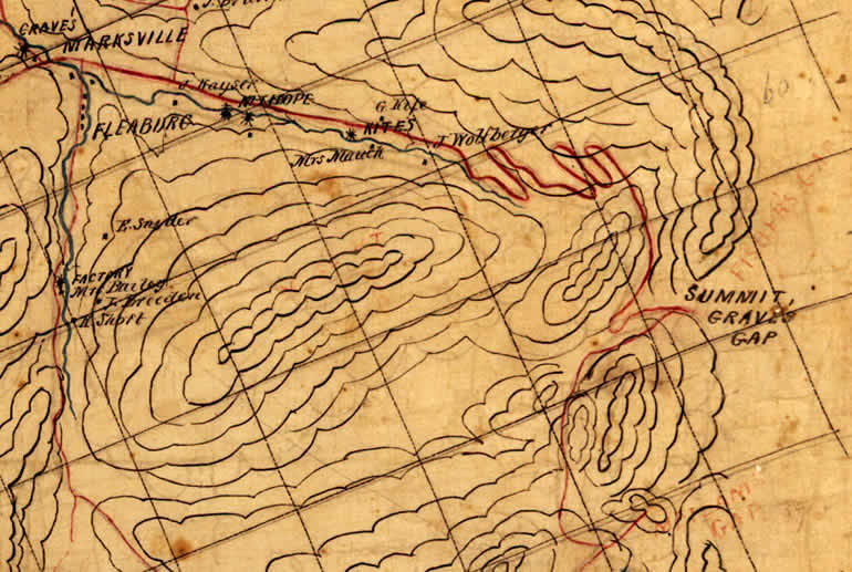
The results of Hotchkiss' "hard day's duty" eventually found their way onto his famous and large (100 x 44 inches) Map of the Valley - map No. 89 (link) - which fulfilled General Jackson's first order. Studying it, we learn that he was given another name for this gap: Grave's Gap. From the location of Marksville and the homesteads of Kite and Wolfberger, we can be certain that the red winding road is the western end of the Gordonsville Newmarket Turnpike. On the right you will first notice the words: "Summit Grave's Gap". If you look closely, you can see that sometime later the words "Fisher's Gap" were written in red pencil just above the word Summit. And if you look even closer, you will see that the words "Milam's Gap" were written near the right bottom margin. Red pencil was not used for landmarks on his original map.
During his service wherever Hotchkiss rode on horseback, he made notes and drew sketches of the roads, terrain and troop positions. Archie P. McDonald described him: "To Confederate soldiers in Virginia he was a familiar sight - one leg cast over the pommel of his saddle, a tall man bending laboriously over his sketchbook and drawing curious lines on a scrap of paper." [212]
 |
Hotchkiss first rode across the gap on the Gordonsville Newmarket Turnpike - East to West - in November of 1862, two weeks before Jackson marched much of his Corps across it. He wrote his wife, Sara, of his journey:
"November 12, 1862
Strasburg, Va.
My Deary:
"....I took my time and mapped the roads as I went....
"....went on to Gen. Lee's Hd. Qrs., about a mile from town and spent the night with his Engineer....got my application from Gen. Jackson approved the next morning
"....you remember how it snowed Friday, I kept myself by the fireside, glad to be in the rickety quarters of a humorous old widower, for he kept a good fire....so I thanked a kind Providence that had so well provided for me, while so many were exposed to the pitiless storm....Saturday I came on through Madison Court House....I reached Criglersville Saturday night and got quarters for Sunday at Mr. Strickler's, a nice place, and so I escaped a cold day's ride again, for Sunday was quite raw....
".....Monday was a fine day, and I had a nice ride across the Blue Ridge, by the crookedest road I have ever seen -- 19 miles across -- but the road is a fine one -- I stopped for the night at the foot of the Mountain. Tuesday I came on to New Market....” [213]
{You may read his entire letter here (link).}
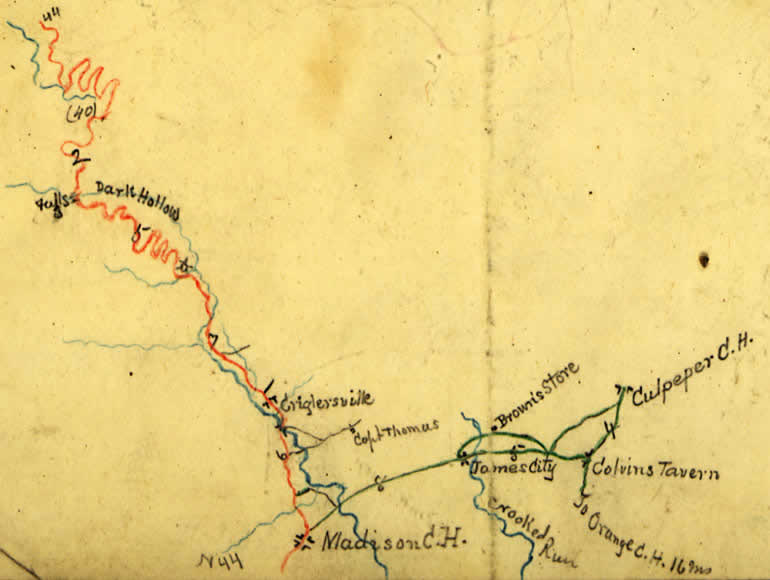
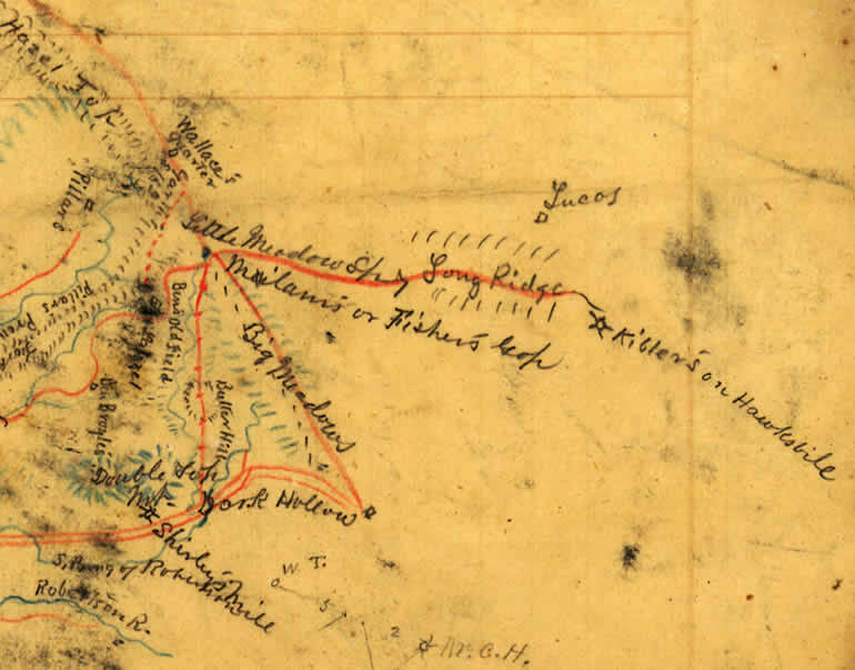
Below, Hotchkiss sketch No. 105 (link) shows his route from General Lee's headquarters at Culpeper Court House through Madison Court House to Criglersville then twisting up the Turnpike along the Rose River past Dark Hollow to Big Meadow then winding down along the Hawksbill Creek into Page County towards Newmarket as seen below.
In addition to sketch No. 105 (link) above, Hotchkiss made a more detailed drawing of the gap area - sketch No. 106 (link) - which indicates Dark Hollow and Big Meadows and near the center of this image the words, "Milam's or Fisher's Gap", as seen below. Hawksbill (Hawks Bill Creek) near the right margin of the image is West and the top margin is South. He notes the Lucas homestead where he spent the night of 21 April 1862. Notice that Hotchkiss again provided two names for the gap - Milam's or Fisher's - as he had in his April 1862 Journal entry: "Milham's or Fisher's Gap".
By the time Hotchkiss' map No. 17 (link) was published (in 1864 or 1865 according to Richard W. Stephenson's Civil War Maps), he had chosen "Milam's Gap" for the name of the pass through which the Gordonsville Newmarket Turnpike ran (as seen at the top left on the map below) .
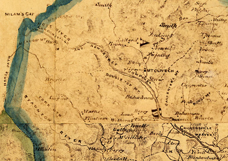
You will notice that Hotchkiss' map No. 17 (link) and Jeremy F. Gilmer's map (link) at the top of this webpage are identical. General J. F. Gilmer was Chief Engineer of the Confederate Army and Major Jedediah Hotchkiss was Top Engineer for Stonewall Jackson. General Gilmer's responsibilities included having maps prepared, printed and distributed to commanders. As such he often utilized Hotchkiss's notes, drawings and maps as a basis for Confederate printed maps. The map at the top of this webpage was printed by General Gilmer's Confederate Engineers Bureau in 1864.
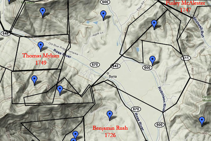
I now direct your attention to the centers of Gilmer's and Hotchkiss' maps where you will see Double Top Mountain and just North of Double Top the turnpike coursing along the Rose River valley. You might recall that Thomas Milam's {Mylum, Mylam, Millam} 1749 land grant was also on the North side of Double Top Mountain. The map below was prepared for me by Robert Vernon and places Thomas Milam's old survey plat on a current topographic map. As you can see, the Rose River ran through Milam's land as would the Blue Ridge Turnpike a century later - commonly called the Gordonsville Newmarket Turnpike. You may compare this map with Mylum's original 1749 plat and survey here (image).
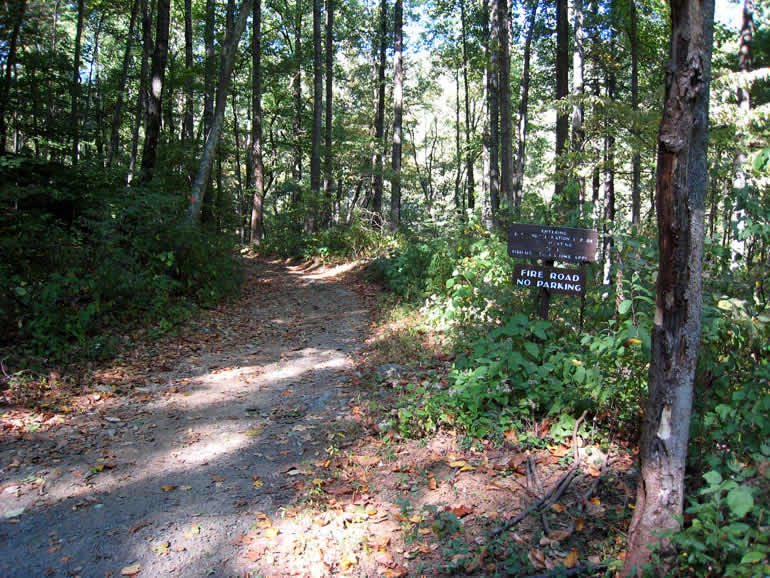
When I visited Milam's old property in 2007, I drove along the Old Blue Ridge Turnpike - Virginia Route 670 - until it dead-ended at the Shenandoah National Park where the old turnpike continued as a "fire road" - winding up the mountain past Dark Hollow and Dark Hollow Falls as in the old days to Big Meadows and the gap. My photo below shows the old turnpike in the Shenandoah National Park which is now named the Rose River Fire Road. It wasn't too much different in November, 1862, when Jed Hotchkiss and shortly later General Jackson's Corps passed over it.
Ann Miller, Senior Research Scientist / Historian, for the Virginia Transportation Research Council has written about this turnpike: "The original enabling act (1848) noted that the road was to be macadamized (link) and required that 'The said road shall be improved at least nineteen feet wide except in difficult places, and shall in no place be less than sixteen feet wide.' " [214] An advertisement (image) for a stage coach service using the Turnpike first appeared in the Richmond Daily Dispatch on 23 April 1853. The sad end of the Gordonsville Newmarket Turnpike was recounted in the Blue Ridge Turnpike Company records of June, 1867: "....the road was used by both armies....whole organization was broken down and the {toll} Gates discontinued...." On 5 June 1867: “....owing to the late war the Blue Ridge Turnpike Company has been disorganized...." My notes from reviewing the records and the drawing are here (link) .
The confusion over the name of this gap continued well into the 20th century when Claude L. Yowell's published A History of Madison County Virginia in 1926. Yowell referred to "Milum's Gap" or "Milum's (Fisher's) Gap" as though they were one and the same. [215] In 1934 when the Shenandoah National Park opened the Skyline Drive, this gap was officially named Fisher's Gap. Not surprisingly, the placement of Milam's Gap some three miles south was not without controversy as Roger L. Payne of the U.S. Geological Survey informed me in an email (see below (link)).
On my very first visit to Thomas Milam's property astride the Rose River, I was struck by the geographic location of his property in relation to the old turnpike which led to the gap at Big Meadows. It seemed likely to me that Thomas was one of the first white men to find a path to this gap. Recently discovered evidence proves that Fisher's Gap was earlier referred to as Milam's Pass and Milam's Gap in land grants, surveys and subsequently in deeds - even in Stephen Fisher's survey and land grant! Indeed it was referred to as Milam's Pass during Fisher's time and even a century later.
Mr. Dewey Lillard who is a fountain of knowledge about Madison County and who researched and authored Land Grants and Surveys of Madison County Virginia found an 1805 land grant to Capt. Thomas Bohannon containing the phrase "....nigh a path called Milan's pass, on the North side of Double Top....". [216, 217] You may view Bohannon's grant here (image). Bohannon's land was located just west of Milam's old farm and near the east entrance to the Rose River Fire Road. The fact that in 1805 Milam's Pass was only a path - probably meaning a bridle path - may explain why it did not appear on important maps.
After I spoke with Dewey about my Milam's Gap project, he searched his extensive files and found the 4 Aug 1778 Northern Neck Land Grant of Stephen and Magdalena Fisher which reads:
"....do give, grant and confirm unto Stephen Fisher of Culpeper County a certain Tract of Waste & ungranted land near Milam's Pass on the Blue Ridge in Culpeper and Shenandoah Counties bounded as by Survey thereof made by Richard Young. Beginning at 2 Chestnuts near a Line of the Manor of Leeds on Top of the Ridge....containing Two hundred & sixteen Acres...." [218]
{ The survey for Fisher's grant was made earlier on 23 May 1770, just ten years after Milam removed to Bedford County. You may view Stephen Fisher's 1770 survey here (image) and his 1778 Northern Neck grant here (image). The deed recording Stephen Fisher sale of this land in 1779 shows that his wife's name was Magdalena. [300] The 1770 survey indicates that one of the Chain Carriers was an Adam Fisher, apparently his brother or son. A personal communication wrote me that this Fisher family moved on to Kentucky in the Fall of 1779. [301]
This is critical information since it proves that Stephen Fisher purchased land which was already recognized as being "near Milam's Pass on the Blue Ridge"!
Mr. Lillard then traced the sales of Fisher's original 216 acres through deed records and found that Fisher's land was ultimately sold to Isaac N. Long, John E. Koontz and A. J. Huffman on 25 July 1894. Their deed is even more detailed and places Fisher's 216 acres and Milam's Gap at Big Meadows:
"....to wit: The tract of 216 acres more or less of land lying in the counties of Madison & Page near what is known as Milam's pass or Milam's gap on the Blue Ridge Mountains being the same land adjoining what is known as the Meadows Tract...." [219]
{You may view Isaac A. Long's 1894 deed here (image).}
As Dewey Lillard wrote to me: "So there it is - Fisher's Gap is the same as Milam's Gap! " [220] On 8 July 1931 Isaac Long's 216 acres were sold to the Virginia State Commission on Conservation [224] who in turn sold the property to the Shenandoah National Park who labeled it Madison County Tract 141. [225] Dewey's conclusion was verified when Mr. Norman Forder, Facilities Services Assistant, Shenandoah National Park, mailed me a photocopy of the 1932 U. S. Geological Survey showing Isaac N. Long's Madison Tract 141 located exactly at Fisher's Gap. [223] You may view the U .S. Geological Survey here (image). This series of land transactions prove that "Fisher's Gap" was named for the Stephen Fisher who purchased the orginal Northern Neck Land Grant in 1778. [218] Furthermore the property records establish that this gap was already known as Milam's Pass or Milam's Gap as early as Stephen Fisher's 1770 land survey. No wonder that Claude Yowell referred to this gap as "Milum's (Fisher's) Gap" in his 1926 A History of Madison County Virginia. [215]
It's rather common for the name of landmarks like mountains, rivers and passes to change over the centuries as later property owners acquire land at the site - especially if the landmark was rather insignificant. For example, in the early 1700s the present day Rose River which runs through Mylam's old property was first known as the "south fork of the Robinson River" then around 1753 as "Row's River" named for George Row who owned property near its head. [222]
The larger significance of the "path called Milan's pass" may be seen on this map (image) of the Counties of Virginia from Milam's era. Orange County where Thomas Milam dwelt was vast extending West across the Blue Ridge and Shenandoah Valley to the Appalachians and beyond – “...bounded....westerly by the utmost limits of Virginia”. [232] During the 1730s and 1740s, the Shenandoah Valley was rapidly settled and the Valley settlers needed a path across the Blue Ridge Mountains to Orange Court House to attend the monthly Court. The path which Thomas Milam discovered although only a bridle path was the most direct route for many Valley settlers, Court Justices, Sheriffs and Surveyors to Orange Court House.
Finally - for completeness sake - in case someone wonders if Milam's Gap was named for a Milam other than Thomas Milam, I can assure them that I searched the land grants, surveys and deed records of Madison and Page Counties (and their predecessor counties: Spotsylvania, Orange, Frederick and Shenandoah Counties). Beginning with indexes to the abstracts of the counties' deeds, I extended my search for Milams to Peggy S. Joyner's three volume Abstracts of Virginia's Northern Neck Warrants & Surveys, Gertrude E. Gray's four volume Virginia Northern Neck Land Grants, the first three volumes of Nell Marion Nugent's Cavaliers and Pioneers, Douglas K. Morris's Database of Shenandoah National Park's Land Records and, of course, Dewey Lillard's Land Grants and Surveys of Madison County Virginia. There was no record of any other Milam owning property in these counties from their origins in the 1700s through the early 1800s during which time the above records were written.
NOTE TO READERS: All the words in bold regular type face are links to photographs, maps or word definitions in the Glossary.
Acknowledgements
This Milam's Gap project was a collaborative effort. I want to thank five knowledgeable persons who were very generous with their time and who provided me essential information and importantly introductions.
- Dewey Lillard was introduced to me by Ms. Ann Miller. He had researched and self-published the Land Grants and Surveys of Madison County Virginia and had found Thomas Bohannon's 1805 land grant with the words "path to Milan's Pass" near Thomas Milam's old land . [216] After our telephone calls and exchange of emails, Dewey searched his files on Big Meadows and found Stephen Fisher's 177o survey and 1778 grant for 216 acres on top of the Blue Ridge and near the Manor of Leeds property line. Fisher's grant contained the words: "near Milam's Pass". Furthermore, he found a re-sale of Fisher's 216 acres in 1894 to an Isaac A. Long which reads: "....The tract of 216 acres more or less of land lying in the counties of Madison and Page near what is known as Milam's pass or Milam's gap on the Blue Ridge Mountains being the same land adjoining what is known as the Meadows Tract....". That cinched it: Stephen Fisher for whom the gap was named bought land whose survey noted that it was "near Milam's Gap". I have had the pleasure of corresponding with Dewey and visiting with him at his home in Shelby, Virginia. I am deeply appreciative of his generosity.
- Ann Miller, Senior Research Scientist / Historian, for the Virginia Transportation Research Council, was introduced to me by my friend, Bob Vernon, who placed Thomas Milam's original land plat on a modern map. Ann through a series of detailed emails told me of the history of the Gordonsville Newmarket Turnpike and provided a reference to her article. [214] She directed me to the files on the Blue Ridge Turnpike Company at the Library of Virginia and gave me suggestions of which counties and what time periods to search. She was of course familiar with the Jed Hotchkiss' maps and Yowell's "History of Madison County Virginia" [215] and gave me her take on the controversy. Furthermore Ann referred me to D. J. Lakes' 1885 "Atlas of Page and Shenandoah Counties, Virginia" and a later 1875 map by Hotchkiss at Virginia Tech University. Finally, Ann provided me a reference to the Thomas Bohannon grant with the quote "....nigh a path to Milan's Pass...." mentioned in Dewey Lillard book and then introduced me to Dewey. [216] Without Ann's generous help, I could not have completed this project.
- Robert Vernon and I met at Library of Virginia's Record's Center. Bob asked me what I was researching. When I mentioned Thomas Milam (1738), to my astonishment Bob began to talk about Milam, the William Rush IV family who lived along Quaker Run, William's daughter, Mary Rush, whom he concluded had married Milam, John Kelly and Finlie McAllister who he thought were Milam's brother-in-laws. Subsequently, he searched his files and provided me references to court records connecting Milam with Kelly and McAllister and the Rush family. In the early 1990s Bob had prepared a map and published an article in 1994 on the earliest land grants along the Robinson River. [21] Subsequently I asked him to extend his map west to include Thomas Milam's land plat which he generously did. I can't imagine how many hours that must have taken him because he needed to find and plot all the land grants in between Milam and the previous group of plats. Bob helped me with this project and, most importantly, he introduced me to Ms. Ann Miller.
- Norman Forder is Facilities Services Assistant, Shenandoah National Park at Luray, Virginia. Mr. Forder sent me an email with Jed Hotchkiss' 1864 map No. 17 as an attachment. At the time, it was the oldest reference to Milam Gap that I had found. Subsequently he provided me the 1932 U.S. Geological Survey map for the proposed Shenandoah National Park. If I had not received the 1864 Hotchkiss map from Mr. Forder, I wouldn't have pursued this project now and may have missed the opportunity of the moment. I plan to see Mr. Forder in Luray and visit the Park museum and view the artifacts which they have.
- Roger L. Payne is with the U.S. Geological Survey, Geographic Names Information System. I had emailed the GNIS for information about Milam's Gap which can be located on their website (link). Mr. Payne responded with this reply:
"In the case of Milam Gap, there was some sort of controversy in 1933. Eventually any documents regarding a controversy will be available online with the entry, but that is a couple of years away. In the meantime, the Board's staff (copied on this response) can check the files and let you know the nature of the problem in 1933. However, we are not so optimistic since files prior to the early 1970s are often missing or sketchy at best but they will check and let you know." [221]
I immediately suspected what the controversy had to do with naming the gap: Milam's Gap or Fisher's Gap. Mr. Payne kindly forwarded my request to Mr. Norman Forder and two others. Apparently there are no files available on the 1933 controversy.
-------------------------------------------------------------------------------------
NOTE TO READERS: All the words in bold type face are links to images, maps or word definitions in the Glossary.The Citations and Glossary are available under the Resources tab or here (link) .