Thomas Milam Culpeper County Land Survey, 15 JUN 1749
Microfilm image of Northern Neck Warrants and Surveys
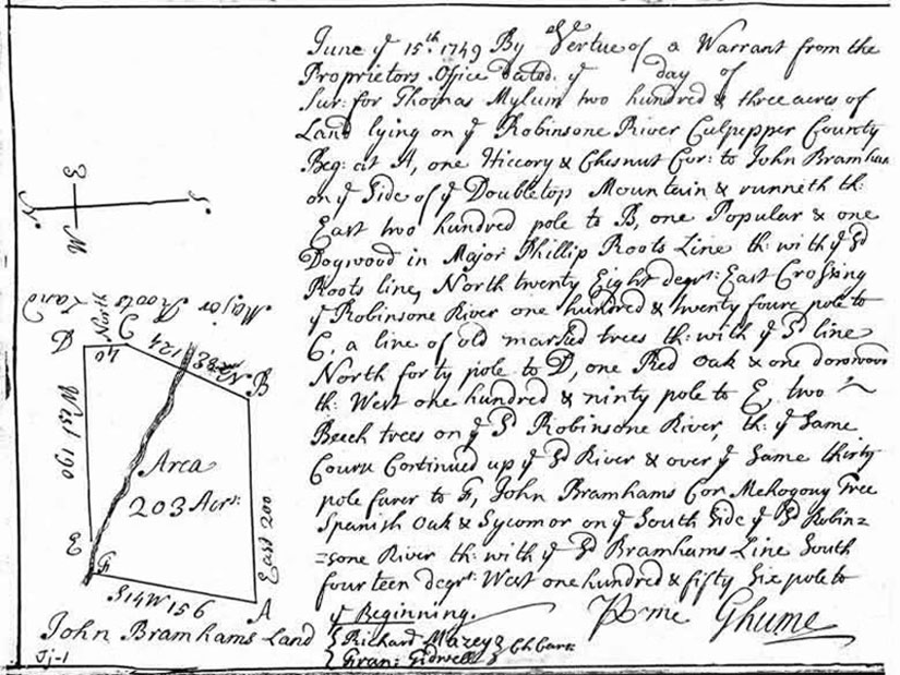
"June ye 15th, 1749. By Vertue of a Warrant from the Proprietors Office Dated ye ___ day of ___ . Survey: for Thomas Mylum two hundred & three acres of Land lying on ye Robinsone River Culpeper County. Beginning at A, one Hickory & Chestnut corner to John Branham's on ye side of Doubletop Mountain & runneth East two hundred polesto B, one Popular & one Dogwood in Major Phillip Roots line.....crossing ye Robinsone River {present day Rose River} ....to C, up ye River and over ye same.....to John Bramham's.....on ye south side of ye Robinson River then with ye Bramham's line.....to ye beginning. Chain Carriers, Richard Mazey and Frances Tidwell. Surveyor, George Hume." [306]
Please note that North is toward the left side of the plat as the arrow shows. Also note the course of the Rose River through Milam's plat and compare it to his plat on a current topographic map by clicking here.
To Top